
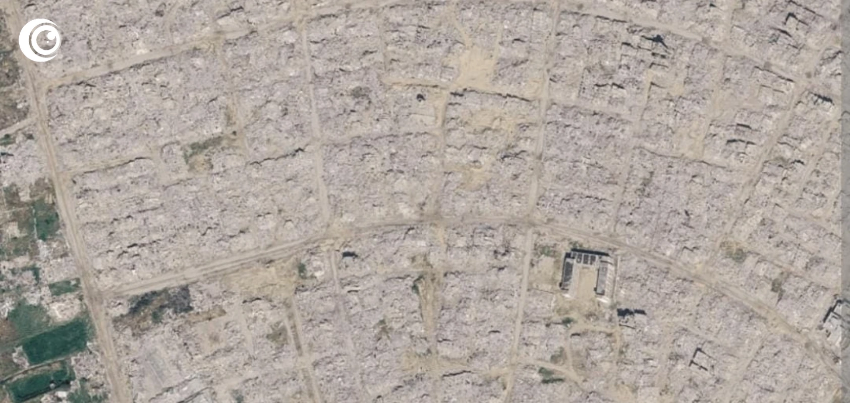



Newly updated Google Earth satellite imagery has brought the devastation across Gaza into stark view, revealing entire Palestinian neighbourhoods reduced to rubble following the Israeli military campaign. Images released in recent days show vast areas of Rafah, Khan Younis and Gaza City where densely populated residential districts once stood, but now appear as expanses of destroyed buildings, debris and bare ground. The imagery offers a striking visual record of the physical destruction produced during the genocide in Gaza.
The scale of the destruction is reflected in United Nations satellite assessments. UNOSAT reported that approximately 201,290 structures around 82% of all structures in Gaza had been damaged. Around 134,422 structures were classified as destroyed, with tens of thousands more suffering severe or moderate damage. The figures demonstrate that the devastation has affected not isolated locations but the overwhelming majority of Gaza’s built environment.
The satellite imagery makes these statistics visible from above. In parts of Rafah, areas that previously contained densely packed homes now appear almost entirely cleared of buildings. In Khan Younis, extensive stretches of residential neighbourhoods have been reduced to rubble. Similar scenes can be observed around Gaza City, including areas surrounding major civilian facilities. The destruction has transformed the physical landscape of Gaza, with streets and neighbourhoods becoming difficult to recognise compared with earlier satellite imagery.
The destruction of civilian infrastructure has compounded the humanitarian consequences for Palestinians. Homes have been destroyed alongside schools, hospitals, roads, water infrastructure and other facilities necessary for ordinary civilian life. The resulting landscape is not simply a collection of damaged buildings; it represents the destruction of the communities and infrastructure upon which millions of Palestinians depended.
The imagery is particularly significant because independent access to Gaza for foreign journalists and investigators has remained heavily restricted. Satellite imagery therefore provides an important means of documenting changes to the territory from above. Recent reporting has also cited estimates that the territory contains tens of millions of tonnes of rubble, illustrating the enormous physical task involved in clearing the destruction before large-scale reconstruction can proceed.
The consequences of the Israeli campaign extend beyond the immediate destruction. Palestinian families who survived the bombardment have been left facing destroyed homes, disrupted livelihoods and the loss of schools, hospitals and essential services. For Palestinians, rebuilding therefore means far more than replacing concrete and infrastructure: it involves attempting to restore communities that have been repeatedly displaced and devastated.
Against this backdrop, the U.S. backed Board of Peace presented a proposed $2.45 billion, six-month reconstruction programme on September 23, covering 66 projects involving infrastructure, healthcare, education, temporary housing, rubble removal and economic recovery. The board estimates that rebuilding Gaza’s physical infrastructure would require approximately $35.2 billion, while broader recovery over the following decade could reach $71.4 billion. Implementation, however, remains dependent on unresolved political and security arrangements.
The proposed reconstruction comes after a campaign whose physical consequences are now visible from space. Satellite images cannot show the grief of families who lost their homes, the lives lost beneath the rubble or the disruption experienced by Palestinians across Gaza, but they reveal the extraordinary scale of the destruction left behind.
What once appeared as dense Palestinian neighbourhoods now appear in many locations as vast fields of rubble. The images therefore stand as a visual record of the consequences of the Israeli military assault on Gaza and of the enormous challenge Palestinians now face in rebuilding their homes, communities and civilian infrastructure.